Call Us:

Search

Pin Parvati Pass Trek

From

₹ 46,000 ₹55,000

Duration

10D/9N

Height

17,400 Ft

Distance

108kms

Pick Up & Drop

Manali

Overview

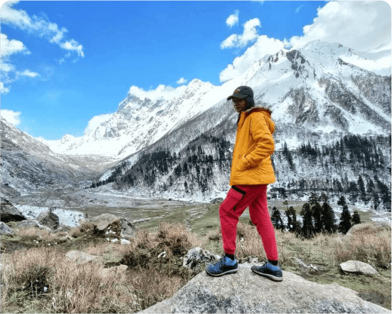
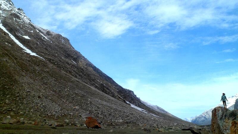
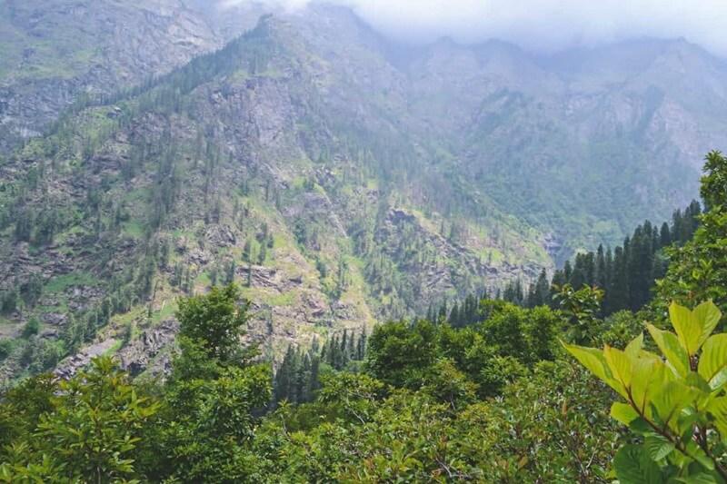
This trans-Himalayan journey, known as Pin Parvati Pass, is considered to be one of the most difficult cross-over treks in the country. It is designed for experienced trekkers who are searching for a challenge. It is your route between two different worlds: the dry, robust, and nearly galactic Pin Valley in Spiti (the freezing desert), which is located in Himachal Pradesh, and the plentiful and living Parvati valley, which begins at the junction of the Parvati river and the Beas river in Himachal Pradesh. As a result of reaching the Pass, which is located at an elevation of 5,298 metres, you will be able to see both worlds simultaneously. This is the prize for reaching the highest point of the walk. It is an experience that cannot be compared to any other. The prayer flags, the panoramic view with the onslaught of greens on one side and browns on the other, and the fact that you get knee-deep in white snow are all part of the experience. The reason the Pin Parvati Pass continues to be our top choice for a cross-over trip in the nation is because of this.

Trek Plan

From Barsheni to Kheerganga

The Barsheni, which is located on the bank of the Parvati River, is the starting point for the trek to Kheerganga. Once you have arrived in Barsheni, you will begin your trekking journey. The journey begins with a walk through dense pine trees, and then all of a sudden, the environment transforms into farms and towns as soon as you pass an iron bridge over a rushing torrent.You make your way through the Himalayan Valleys, which are known for their breathtaking scenery, on your approach to your hike. As you continue your journey from Kasol to Kheerhanga, you will come across a number of waterfalls. to a later time, you arrive to Rudra Nag and make a little stop to take in the breathtaking scenery and snap pictures of it. During this trek, you will get the chance to engage in conversation with the locals and gain an understanding of their way of life as well as their culture. After you have arrived at Kheerganga. Everyone finds themselves drawn to the beautiful wildflowers as well as the enormous oaks and deodar trees. In the evening, before retiring to your tents for the night, you should take part in a musical performance that is both entertaining and informative.

From Kheerganga to Tunda Bhuj

The trek will begin at Kheerganga and end at Tunda Bhuj. This is a steady hike, and from there you will be able to see the Parvati river firmly flowing down from the mountains. This sight is so breathtaking that it will convince you that hiking in Manali is the most incredible experience you could ever have. The path from Kheerganga will be the first stream that will be crossing start with a constant ascent for approximately 20 metres. Later on, the trek will be heading towards the stretched meadows land, and the chirping of birds will be with you the entire time, like a fellow who will entertain your ears throughout the entire journey of the third day. When it comes to trekking in Himachal Pradesh, later on, your path, you will see the bridge over the edge of the mountains, and after approximately thirty metres, you will cross the forest area and enter into the meadows. Kheerganga is the most sought-after destination, and it is also the spiritual destination that comes after the name of Lord Shiva. This sight will feel like a wonderful window scene when you open the curtains in the morning and watch the amazing view in front of you. Now, as you make your way across the meadows, you will be heading to the greater altitude at the high peaks. As soon as you reach the peak, you will be able to take in the breathtaking panorama of the Parvati Valley, which will send shivers down your spine. As you cross the last flyover and enter your destination at an elevation of 10,500 feet, you will be able to see the gigantic mountains that are covered in snow. This will be the point at which your entire adventure of reaching Tunda- Bhuj will come to an end.

Tunda Bhuj to Thakur Kuan

When you are going down from Tunda Bhuj towards Thakur Kuan, you will cross your way through the pastureland with the flora, and the relaxing green will continue to be your companion throughout your journey. The third day will be ahead of you in the direction of Thakur Kuan. It is a well-known truth that green is the most calming hue when it comes to the eyes and the mind. Additionally, the most enjoyable aspect of hiking in Manali is the amount of greenery that can be found there. Although the landscape view of Tunda Bhuj is simple to appreciate, the distance that you will go is somewhat more extensive due to the fact that the bridge that you will cross is a lengthy one that will need a significant amount of time. After some time has passed, you will be traversing the rocky meadow terrain, and it will take you around 15 metres to reach the steady rise. It is generally known that trekking in Himachal Pradesh is the most beautiful and exciting activity. The greenery of pasturelands was used to establish the four moons in the Manali trekking, and the destination itself is a complete combination of rocks and greenery. Now, as you make your way towards your route, you will be able to take in the breathtaking scenery that will undoubtedly reawaken the photographer that resides within you. The scenery is so breathtaking that you will want to take pictures of it. Following your traversal of the Pandu Bridge, you will make your way down towards the Parvati River, which is located on your right side. The journey through the fields will take around fifteen minutes. Following all of the efforts that you have put forth in order to reach the Thakur Kuan, you will be there by the evening. The Thakur Kuan is located at an elevation of 11,000 feet.

From Thakur Kuan to Odi Thach

Because the previous day was a little bit exhausting, you will feel wonderful after getting a good night’s sleep because the fifth day will be full of exciting and enjoyable activities, and this day will be an easy day in your entire journey to Pin Parvati Pass trek. You are going to traverse the terrain region, and after that, you are going to go by the numerous streams that are coming your way. In the future, you will once more have the opportunity to observe the Pin Parvati River, which will be of great assistance to you and will provide you with a breathtaking perspective. With the help of green trekking in Manali, you will be able to observe the vast woods and meadows that are located in the area, in addition to the Parvati River. This will provide you with the opportunity to learn the valuable lesson of maintaining the vitality of the place, which is beneficial to both your body and your mind. The Thakur Kuan region is surrounded by pastures of orchard blossoms and tiny trees, and it is recommended that trekkers form a group in order to travel under the natural bridge. Once you have traversed the woodlands and meadows, you will enter the Thakur Kuan region. The route will be simple since it will be on flat land, which means that you won’t have to exert much effort to go ahead. Additionally, there will be several water points before Pandu Bridge where you can replenish your water bottles, and once you have exhausted all of your options, you will arrive at Odi Thach. The picturesque location of Odi Thach, which is nestled in the Himalayas, will provide you with a breathtaking panorama of the mountains against the backdrop of the sky, which will appear to be a miracle in the actual world. The adventure will continue to follow you, but even if you only catch a peek of the fifth day, you will have a greater understanding of how lovely the experience of hiking in Manali is.

From Odi Thach to Mantalai Lake

On the fifth day, you will go around 12 km, which will take you approximately seven to eight hours to complete. As a result of the fact that this path will be muddy, which might cause slipping, it is very necessary to exercise caution on this particular day and to have the ideal trekking boot. Later on in your journey, you will come across the moraine region, which is located after the muddy trail; the rise will be steep and will demand you to exert a lot of physical energy. It is thus recommended that everyone, before to beginning their trip towards Pin Parvati Pass, engage in physical activity for a minimum of two months. This will ensure that you are able to retain the essential stamina during the duration of this walk. You may see a few temples that are located there and have a history behind them. The voyage will be so spiritual and exciting that you will be decisive during the entire trip. Mantalai Lake is the beginning point for the Parvati River, and on the route, you can also visit a few temples that are positioned there. Because Mantalai Lake is located at a higher altitude, there is a possibility that you may have symptoms of acute mountain sickness (AMS) at your last campsite, which will be around forty-five minutes away from the lake. However, you do not need to be concerned about it since our guide will provide you with all of the necessary measures. In addition to that, you should also bring your medications with you so that you can take care of your own body.

Acclimatization Day at Mantalai Lake

This day is a buffer day for you. This day you can relax and acclimatize yourself for this weather change and upcoming change also.

From Mantalai Lake to Base Camp

On the seventh day, after seeing the breathtaking splendour of Mantali Lake, you will traverse the river lane, which will be quite exhausting for the day walk. After that, you will go through the high rocky areas and glaciers. Later on, you will walk to the right side of the hill, following the lengthy route that lasts for around nine to ten hours. The seventh day will be full of exciting adventures, and you will need to be in good physical and mental health in order to fly the trip. Climbing the mountains that are higher than 14,850 feet will take a considerable amount of time; after that, you will have to go to the location where you will be camping, where the steep rocks will make you exhausted since the entire journey will be difficult until the seventh day. When you finally get at the top camp, you will be surrounded by verdant vegetation all around you, and the glaciers will give you the impression that you are in heaven on earth. Due to the fact that the day will be so exhausting, it is recommended that you bring all of the necessary precautions with you, such as water bottles that are full of water and nutritious food that you pack in order to replenish your energy. Additionally, it is conceivable that due to the high altitude, one may have amnesia, but you need not be concerned about this since our guide will be there to protect you. Before you go on the journey to Pin Parvati Pass, it is imperative that you take care of your health and give it the attention it deserves. Considering that it is a challenging graded pass trek, it is best to get yourself ready for all the uncertainties that you will encounter throughout your Pin Parvati Pass Trek. However, the magnificent scenery and the fun you will have along the way will help you feel refreshed and will keep you calm throughout the entire journey.

Cross Pin Parvati Pass to Pin Valley

As we make our way towards Spiti, we will get an early start today because today is the day that we will be obtaining the pass. When you leave camp, you will have to go across the massive ice and snowfield that leads to the pass. In order to overcome the crevasses and ice slopes on glaciers, we need to navigate them. We proceed to make our way to the pass by following the footprints and track left behind by the guide. It is estimated that it will take us between three and four hours to reach the Pin Parvati pass (6,300 metres or 17,400 feet). On the last section, there is a rocky ridge that requires a bit of a tough ascent. Due to the fact that the ice gets more unstable as the sun continues to move, it becomes more difficult to walk to snow. Because of this, it is suggested to get an early start when the snow and ice are still solid. It is also possible to reach the peak before midday, which results in a bright sky. However, as the afternoon progresses, clouds from the valley begin to appear, which causes the view to gradually diminish. Views of the valley of Spiti and the surrounding mountains may be seen from the pass. After making a gentle drop on snow and ice, we next make a rapid plunge on rough scree on the second descent. Upon arriving at the base of the pass, we traverse a stream that is very cold and arrive at the Pin side base camp, which is located on a patch of grass on the left bank of the Pin River. The camp is 4,400 metres (14,450 feet) in elevation.

From Pin Valley to Mud Village

As we make our way out of camp today, we will be hiking through a valley that is so vast that it is covered in a multitude of streams. With the colours of the terrain reaching all the way up to the top of the mountains and the greenery at the bottom of the valley, the landscape view of Pin Valley is really breathtaking to see. We continue on a path, and just before we reach Mudh, we make a pit break for lunch. When we finally arrive at Mudh, the first settlement in Pin Valley, we make a pit stop for a cup of tea and a visit to a guesthouse store to sample some Himalayan food. Stay for night here and relax after dinner.

From Mud Village to Kaza -Manali

Your journey will take you back to the Kaza. On this day, which would be the final day of your trek across Pin Parvati Pass, you would gather all of the memories you have accumulated and then drive back to Kaza, from whence you will continue on to Manali the following day, and with the rest of your adventure. Now that the final day has arrived, you will be making your way towards Manali by following a route that you are already familiar with, all the while carrying the memories of the whole Pin Parvati Pass walk with you. This is the final day of your Manali trekking vacation, and we must say that you will miss the entire excursion. However, as the old saying goes, nothing is permanent, but memories are, so remember to keep the positive vibes going; schedule another trip to Himachal Pradesh so that you may experience the peaceful vibes of trekking.

What’s Included

What’s Excluded

Things To Carry

When embarking on a trek with Global Events Travels, there are certain items you need to bring yourself. These are divided into five categories: Trekking Gear, Footwear, Clothing, Toiletries, Utensils, and Miscellaneous. All items listed are essential, unless marked as optional.

Trekking Gear

  • Rucksack with rain cover
  • Day pack bag, Recommended for treks with a summit day
  • Head torch with spare batteries
  • UV protection sunglasses
  • Water bottles: Two 1-liter bottles

Footwear

  • Non-skid, deep treaded, high-ankle trekking shoes: 1 pair
  • Lightweight slippers or sandals: 1 pair
    Clothing
  • Quick-dry warm lower or track pants: 2
  • Full-sleeve T-shirts/sweatshirts: 1 for every 2 days of trekking
  • Thick woolen socks: 1 pair for every 2 days of trekking
  • Thermal body warmer (upper & lower): 1 set
  • Undergarments: 1 for each day of trekking
  • Warm jacket (closed at wrist & neck): 1
  • Full-sleeve sweater: 1
  • Rainwear (jacket & pants): 1 set
  • Waterproof, warm gloves: 1 pair
  • Woolen cap**: 1
  • Sun-shielding hat: 1

Toiletries

  • Personal toiletries kit: Small towel, toilet paper, paper soap, bar soap, toothbrush,
    toothpaste, cold cream, etc.
  • Sunscreen lotion: Small pack
  • Lip balm: Small pack

Utensils

  • Small, lightweight, leak-proof lunch box: 1
  • Plate: 1
  • Spoon: 1
  • Tea/coffee mug (plastic): 1

Miscellaneous

  • Camera: (Optional)
  • Personal medicines: Bring plenty if needed; consult your doctor before the trek.
  • Dry fruits, nuts, chocolate bars (Optional)

FAQ's

The best time to do the Kedarkantha Trek is typically from December to April when the region experiences snowfall and the landscapes are beautifully covered in snow. However, the trek can also be done during the summer months, from April to June, when the weather is milder and the snow has melted.

The Kedarkantha Trek is considered to be of moderate difficulty. It involves trekking through varying terrain, including forests, meadows, and snow-covered trails. While it's suitable for beginners, some prior trekking experience and a reasonable level of fitness are recommended.

The Kedarkantha Trek typically takes around 5 days to complete. This includes trekking from Sankri village to the Kedarkantha summit and back, with overnight stays at various campsites along the way.

The summit of Kedarkantha Peak stands at an altitude of approximately 12,500 feet (3,800 meters) above sea level.

Accommodation during the Kedarkantha Trek typically consists of tents or guesthouses at various campsites along the route. Some operators also offer fixed tented camps with basic amenities like sleeping bags, mattresses, and meals.

Essential items to pack for the Kedarkantha Trek include appropriate clothing (layers for cold weather), trekking shoes, a sturdy backpack, water bottles, energy snacks, sunscreen, sunglasses, a hat, personal medications, and a first aid kit. It's also advisable to carry a trekking pole and a good quality sleeping bag.

While the altitude of Kedarkantha Peak is not extremely high, some trekkers may experience symptoms of altitude sickness, especially if ascending too quickly. It's important to acclimatize properly, stay hydrated, and listen to your body. If symptoms persist or worsen, it's advisable to descend to a lower altitude.

Meeting Point

Trek Gallery

GST 5% Extra

₹ 46,000 ₹55,000

For Group Booking

Other Related Treks

GST 5% Extra

₹46,000₹55,000

Please Fill the Form & Our Representative Will Reach You Shortly